Groundwater's contribution to Christchurch's liquefaction
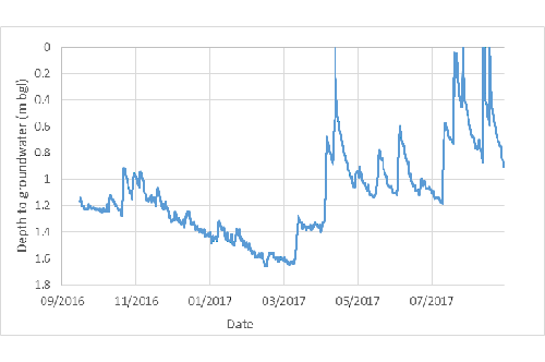
Groundwater level responses in one of the piezometers from September 2016 to September 2017. Note the limited response to rainfall during the summer recession, but the more significant responses after April 2017 when recharge commences and groundwater levels recover. Table: Aqualinc.
Dr Helen Rutter, Aqualinc’s
Shallow groundwater is increasingly under scrutiny in urban areas. It plays a role in surface water flooding, as it can rise to the surface and contribute to flooding. Even when groundwater levels are close to, but not at the surface, the proximity of the water table to the ground surface limits the amount of water that can infiltrate. The Christchurch Earthquake sequence of 2010-2011 saw severe liquefaction - the process where sand and silt grains are rearranged and the water in the spaces between the grains is squeezed. The pressure causes silt and sand grains to float in the water, and the soil behaves more like a liquid than a solid. Again, shallow groundwater increases the potential for liquefaction to occur, and the severity of the liquefaction.
Dr Rutter explains that a network of over 1000 shallow piezometers (each less than 8m deep) was installed by EQC in 2011, to provide information about shallow groundwater to input into assessment of liquefaction vulnerability. Around 1000 holes were being monitored manually on a multi-week schedule. “In 2016, 249 of the sites were instrumented with water level and water temperature sensors, logging every 10 minutes. “
“Continuous monitoring of shallow groundwater has allowed observation of the highly dynamic shallow groundwater system, and has recorded patterns of groundwater level responses that were previously unknown. This has huge potential value in understanding the variability of groundwater levels, and the consequent effects on liquefaction potential, antecedent conditions to flooding and general issues of rising groundwater with sea level rise and climate change.”
Early observations suggest that high rainfall events can cause a short-lived spike in groundwater level of up to a metre higher than usual in some areas, but a much more damped and delayed response in others. The 249 piezometers show a wide range of groundwater level responses to rainfall and other drivers, responses that were previously unseen with weekly or monthly measurements.
“This continuous monitoring of the network has already provided a world-class dataset that highlights the variability of the shallow groundwater system under
Funding is now being put in place by EQC, ECan and CCC to maintain the monitoring system for the next few years. During this time, there will be the opportunity to assess the data in further detail, determine processes driving shallow groundwater levels, and potentially develop operational and management approaches to better manage flood and other risks associated with shallow groundwater, and improve the understanding of liquefaction vulnerability.
Dr Rutter would like to acknowledge the support of EQC for funding for the network and the subsequent analysis of data.
Date posted: 19 June 2018