Land & Water Science takes physiographic approach
Example of the physiographic mapping undertaken for the Waituna Catchment, Southland. Image: Land & Water Science.
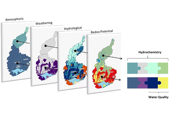
Land & Water Science, based in Invercargill, has been using a physiographic approach to several key research projects on New Zealand’s water quality. The physiographic approach is an integrated or ‘systems view’, which links landscape attributes and the key processes governing water quality outcomes in surface and shallow groundwater. For example, the relationship between soil drainage (attribute) and redox (process - reduction of oxygen and oxidation) can be used to predict soil denitrification potential.
Unlike other mapping and classification approaches, the physiographic approach incorporates water quality, hydrochemical, and/or hydrological response signals into a spatial format to identify, select, combine, and classify those landscape gradients that drive variation in water quality outcomes.
Land & Water Science Director Dr Clint Rissmann says that physiographic science offers an increased understanding of the landscape processes, which then allows for implementing management practices within the local and catchment-scale.
“Examples of ‘on the ground’ management practices that can be implemented and which are informed by physiographic science include land use management practices such as changes to nutrient and stock rates and inputs; implementation of physical mitigation measures such as riparian planting of waterways; peak runoff structures to reduce sediment during high flow and heavy rainfall events; optimisation of the timing of fertiliser and dairy effluent irrigation; and provision of spatial context to existing farm extension programmes.”
Physiographic Environments of New Zealand
The Physiographic Environments of New Zealand (PENZ) is a three-year project co-funded by Our Land and Water | Toitū te Whenua, Toiora te Wai National Science Challenge and regional councils that links fresh water to the land. Understanding this relationship is crucially important as it is a major influence over water composition, and hence quality. For instance, landscape features can account for more than twice the variability in water quality than land use alone. For this reason, it is important to include landscape attributes in an attempt to explain ‘how’ and ‘why’ water quality varies across a catchment or region.
“Physiographic Science turns existing thinking on its head because it uses the signals in water to trace the water’s journey through the landscape,” says Clint.
Waituna Catchment - High Resolution Physiographic Units
Land & Water Science has been working in collaboration with Living Water (a DOC/Fonterra Partnership) and local landowners to undertake high-resolution physiographic mapping of the Waituna Catchment in Southland. The Awarua-Waituna wetlands, encompassing the Waituna Lagoon and the peatlands of the Awarua Plains, are among the last relatively unmodified expanse of wetlands left in New Zealand.
The key aim of the project is to support water quality and biodiversity investment decisions for the catchment, and to assist the partnership in achieving their aim of “finding solutions to enable farming, freshwater, and healthy ecosystems to thrive side-by-side”.
“To achieve this, we created high-resolution physiographic science process-attribute layers for the catchment. The hydrological and redox process-attribute layers were identified to be the key controls over water quality outcomes in the Waituna Catchment.”
One of the outputs of the project was the provision of ESRI-supported story maps including a story map on Background and Technical Information and Waituna Catchment Physiographic Units and inherent risk to water quality.
The Land & Water Science research team also published a research paper on the application of the physiographic approach to the Waituna Catchment, which was presented at the Massey University, Fertilizer and Lime Research Centre Workshop.
Read more – projects by Land & Water Science >>
More Information
The full text of a recent paper published in the journal Science of The Total Environment - “A hydrochemically guided landscape classification system for modelling spatial variation in multiple water quality indices: Process-attribute mapping”, is available from Clint for those who would like to do more in depth reading on physiographic mapping. Follow the link for the abstract.
Date posted: 2 December 2020